Web Map Service layers are map layers that streamed over the internet. Advantages of using a WMS layer are that you can access large files, like a high resolution image, without having to download it. They are also nice because if the file is updated, you don't need to redownload it, the service will be as up to date as the publisher can make it. However, this also means that you need a good internet connection. Another advantage is that a WMS layer is seamless whereas if I download two counties individual data there is not always a good alignment on the edges.
Here are some sites that support WMS data layers for Iowa as well as nation:
- Iowa Geographic Map Server - This site provides current (2011) and historic (1970s and 1980s) statewide imagery.
- Iowa Environemental Mesonet (Scroll to near the bottom of the page for list of available layers) - This site has a lot of weather data (visible, infrared, precipitation) for both Iowa and the United States.
- NASA Socioecomic Data and Applications Center (SEDAC) - SEDAC provides information about a number of national and global indicators including poverty mapping, natural disaster hotspots, global fertilizer and manure application rates, and many others.
Below are instructions for adding a 2011 Iowa orthophoto in both ArcMap and Quantum GIS.
Here’s how to set up a WMS layer in ArcMap:
1) Open ArcMap. Click on the yellow add data button.
2) Open the “Look in:” drop down menu, scroll down and select
“GIS Servers”
4) Paste the following in the URL box http://ortho.gis.iastate.edu/arcgisserver/services/Ortho/naip_2011_nc/ImageServer/WMSServer?
5) Click the “Get Layers” button and then “OK”
6) Select “Ortho_naip_2011_nc….”
7) Click “Add”
Here's how to set up a WMS layer in Quantum GIS:
 1) Open Quantum GIS. Click on the “Add WMS layer” button, this will bring up the “Add layer(s) from a Server” window.
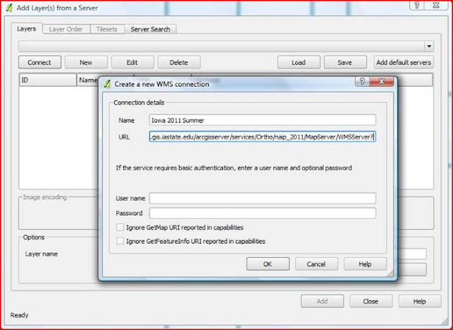
2) In the “Add layer(s) from a Server” window click on the “New” button in the upper left hand side near “Connect”. This will pop up the “Create a new WMS connection” window.
 3)
Name the layer Iowa 2011 Summer in the “Name” box
and in the “URL”
box
below enter in this link: http://ortho.gis.iastate.edu/arcgisserver/services/Ortho/naip_2011/MapServer/WMSServer?,
once added then click on the “OK” button.
4)
Now you should see “Iowa 2011 Summer” in
the layers drop down menu, click on “Save” and
then click on “Connect”.
5)
Once the layers appears click on the ID:1, Name:0, Title:naip_2011,
Abstract:naip_2011,
once its highlighted in blue then click the “Add” button
in the lower right hand corner. Once the layer has loaded (may take a minute)
then click “Close”.


No comments:
Post a Comment